Space-Enabled Modeling of the Niger River to Enhance Regional Water Resources Management (SEMOR)
Home|Space-Enabled Modeling of the Niger River to Enhance Regional Water Resources Management (SEMOR)
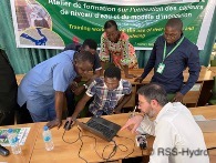
Lead partner: RSS-Hydro (LU)
Local partner: AGRHYMET
Edition: 2021
Country: Niger
Status of the project: Finalized
BPF financing: 24 400 €
Objective of the project:
Set up a low-cost and sustainable space-based ICT solution that will be transferred and maintained by the public partner institution, AGRHYMET, in Niger. The solution uses industry-proven affordable small water level sensors complemented by public, open-access satellite Earth observation (EO) data and RSS-Hydro’s drones for local river and floodplain topography to build a flood inundation model as well as a low-cost but sustainable river monitoring network along the middle reaches of the Niger River Basin in Niger.
This tool will allow water resources planification and management and thus limit damages including destruction of crops and loss of livestock.